National Hurricane Center: Hurricane Sandy 2012 Path Turns Toward New Jersey, NYC (Track Map)
The National Hurricane Center has issued its morning update on Hurricane Sandy, reporting that its winds have increased to 85 mph, which is still a moderate Category 1 hurricane.

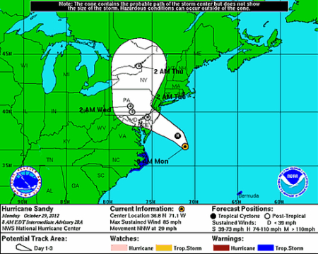
Hurricane Sandy has, as predicted, begun to move off its northward bound course, and is now turning westward towards the U.S. East Coast.
Sustained winds of more than 30 mph have been recorded across the New York City area, and wind gusts of more than 50 mph have been felt at La Guardia Airport in New York.
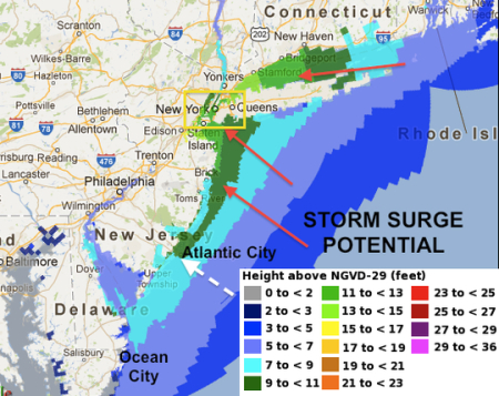
The hurricane is moving at about 15 mph and is expected to make landfall late tonight within a few hours of midnight. On its current track its center will make landfall at southern New Jersey, which will create a massive storm surge across that region as well as up to the New York harbor areas.
Sandy's hurricane force winds are currently extending out 175 miles of its center, and Tropical Storm force winds extend out about 485 miles from the center. It is expected to extend out even further once it reaches the coast.
Despite Sandy only being a Category 1 hurricane, its Pressure level is 946 mb (27.94 inches) which is equal to a Category 3 storm.

It has been predicted that nearly 400 miles of coastline will feel the severe impact of the hurricane force winds and storm surges.
The strongest storm surges will be felt north of where Hurricane Sandy makes landfall, as a funneling of water drives up 8 to 10 feet of water into New York City. South of landfall the storm surge could be about 3 feet high at Ocean City, MD.
Rainfall is expected to be heavy and about 6 inches of rainfall is expected in many areas. That will drench some ground and will make trees more susceptible to being uprooted by the strong winds.
Leaves could also pose a problem as they pile up and block storm drains, further adding to the expected flooding.
The new predictions for extensive flooding will be amplified further by the astronomical High Tide on Monday evening with the Full Moon.
In Western Maryland, and western parts of PA and West Virginia there could be more than 1 foot of snowfall.


